
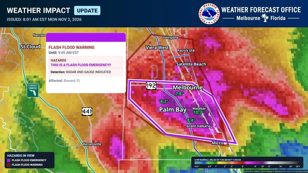
Update, 9 a.m. Monday, Nov. 2, 2026: The National Weather Service in Melbourne issued a flash flood emergency for West Melbourne and Palm Bay at 7:56 a.m., in effect until 9:45 a.m. "Between 8 and 12 inches of rain have fallen," the warning says, based on radar and automated rain gauges, with 4 to 6 more inches possible. "This is a PARTICULARLY DANGEROUS SITUATION. SEEK HIGHER GROUND NOW!" it says, and it tells people not to travel unless they are fleeing an area subject to flooding or under an evacuation order. The warning rates the flash flood damage threat as "catastrophic." It lists Palm Bay, Melbourne, Malabar, Indialantic, West Melbourne, Melbourne Beach, Grant-Valkaria, Micco, Melbourne Village and the Melbourne airport among the places affected.
Melbourne police said at 8:51 a.m. that Babcock Street at University Boulevard, all of Dairy Road and Lake Washington Road were closed. Police had earlier closed Aurora Road in the area of Stewart Road. "Please stay home, and avoid flooded roadways," the department said. Brevard Emergency Management said at 8 a.m. that portions of Interstate 95 may have standing water, and at 8:15 a.m. it asked residents to limit water use, such as keeping showers short and running dishwashers only when full, because the rain is putting stress on the wastewater system.
In northern Brevard, a flash flood warning for Titusville, Mims and Port Saint John was extended until 10 a.m. It says 3 to 5 inches had fallen there.
Elsewhere in Florida, the Weather Service in Tampa Bay issued a flash flood warning at 8:01 a.m. for eastern Hardee, northern DeSoto and northwestern Highlands counties, including Sebring, Avon Park, Arcadia and Wauchula, until 9:30 a.m. It says 5 to 8 inches of rain had fallen there. A flood watch covers Polk, Hardee, DeSoto and Highlands counties until 3 p.m.
Earlier Monday:
MELBOURNE, FL, Nov. 2, 2026 — Heavy rain that kept falling over Brevard County overnight left roads flooded across the county early Monday, and Brevard Public Schools canceled classes for the day.
The National Weather Service in Melbourne issued a flash flood warning for southern Brevard County at 4:44 a.m. that runs until 7:45 a.m. "Between 6 and 8 inches of rain have fallen," the warning says, with 2 to 4 more inches possible. It calls the flooding "life threatening" and lists Palm Bay, Melbourne, West Melbourne, Rockledge, Satellite Beach, Indialantic, Malabar, Merritt Island and Viera among the places affected.
A second warning, issued at 4:58 a.m. for northern Brevard until 8 a.m., covers Titusville, Mims and Port Saint John. It says 2 to 4 inches had fallen there, with 2 to 3 more possible. At 6:30 a.m., the Weather Service said a stalled boundary was still producing "training bands of showers and storms" with heavy rain.
Brevard Emergency Management said at 7 a.m. that it's aware of "widespread road flooding, especially in the south end of the county." It asked people who don't have to be out to stay home and not to drive on flooded roads. The office also confirmed that Brevard Public Schools canceled school for the day, which FOX 35 and WFTV also reported.
In Melbourne, police said flooding was occurring throughout the city and that Sarno Road was closed near Eau Gallie Boulevard.
The Weather Service's flood watch for east central Florida, including Brevard, Volusia, Orange, Seminole, Osceola, Lake, Indian River, St. Lucie, Martin and Okeechobee counties, runs until 7 p.m. Monday. It says the ground is nearly saturated and localized totals of 5 to 7 inches or more are possible. Farther south, the Weather Service in Miami has a flood watch for South Florida through Monday evening.
The St. Johns River is also rising. A Weather Service flood warning says the river near DeLand was at 4 feet, its flood stage, at 5:30 a.m. Monday. It's expected to crest at 4.1 feet this evening and fall below flood stage early Friday morning.
Forecasters say never to drive into flooded roads. If you see water over the road, turn around and find another way.
Launchpad Digital will update this story as the Weather Service and local officials release more information.
Those are the facts, directly from the source.
Sources: NWS Melbourne flash flood emergency, 7:56 a.m.; NWS Melbourne on X, 7:59 a.m.; Melbourne Police on X, 8:51 a.m.; Melbourne Police on X, 7:46 a.m.; Brevard Emergency Management on X, 8 a.m. and 8:15 a.m.; NWS Tampa Bay on X; National Weather Service Melbourne on X, 4:45 a.m.; NWS Melbourne on X, 6:30 a.m.; NWS active alerts for Florida; Brevard Emergency Management on X; Melbourne Police on X; FOX 35; WFTV.
← More Local stories · All Launchpad stories · Spotted an error? Request a correction.