
MELBOURNE, FL, Oct. 28, 2026 —
Coastal flood warnings remain in effect Wednesday along most of Florida's Atlantic coast and in the Florida Keys, and National Weather Service offices have extended them for Northeast and East Central Florida until 2 a.m. Friday, according to warnings issued early Wednesday.
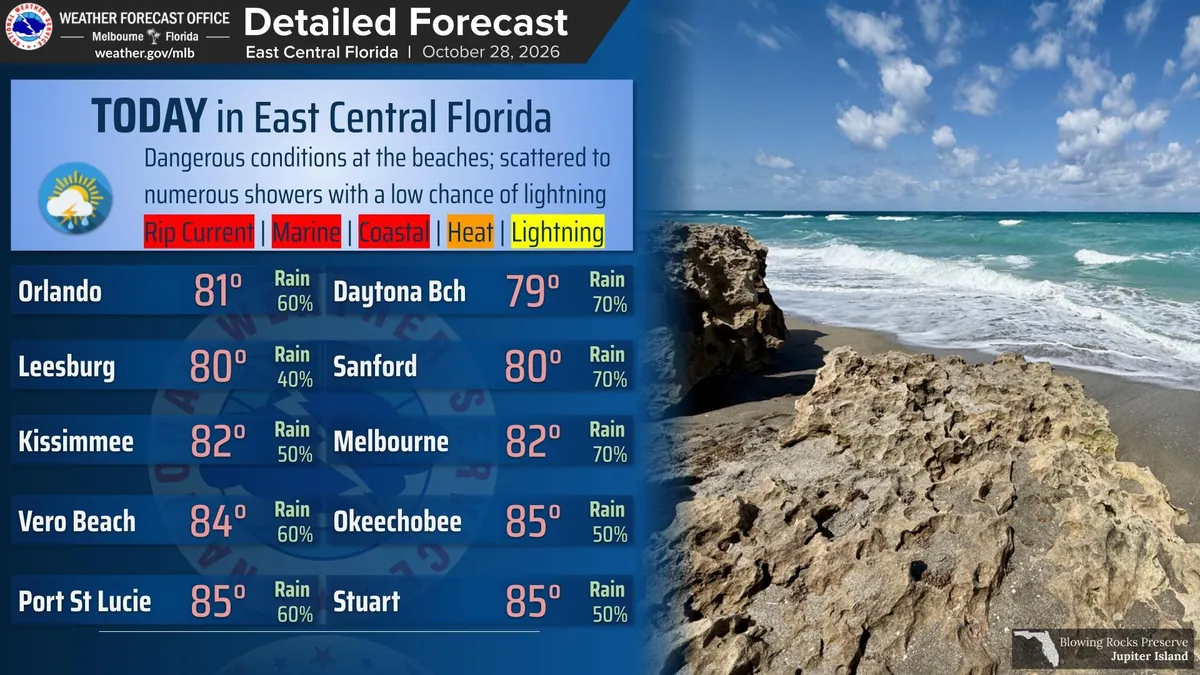
"It is advised to not enter the surf! Dangerous conditions continue at the east central Florida beaches and local Atlantic waters," NWS Melbourne posted Wednesday morning.
Where the warnings are, and how long they last
- Space Coast and Treasure Coast (coastal Volusia, Brevard, Indian River, St. Lucie and Martin): NWS Melbourne's coastal flood warning for significant coastal flooding runs until 2 a.m. Friday, with a high surf advisory for breaking waves of 7 to 11 feet and a high rip current risk through late Friday night. The office says "significant shoreline erosion will occur" and that "swimmers should remain out of the water."
- Northeast Florida beaches (coastal Nassau, Duval, Flagler and St. Johns): NWS Jacksonville's warning for moderate flooding at high tide runs until 2 a.m. Friday, with breaking waves of 7 to 9 feet and a high rip current risk through Friday evening.
- St. Johns River basin (inland Flagler, eastern Clay, eastern Putnam, south-central Duval and western St. Johns): a separate warning for moderate flooding at high tide also runs until 2 a.m. Friday.
- Florida Keys: NWS Key West's warning for "major saltwater flooding" covers the Upper, Middle and Lower Keys until 5 a.m. Thursday, "especially at the times of high tide with little relief during the periods of low tide, especially in the Upper Keys."
- Palm Beach, Broward and Miami-Dade coasts: NWS Miami's warnings for Broward and Miami-Dade and Palm Beach run until 8 p.m. Wednesday, followed by a coastal flood advisory for moderate flooding until 8 p.m. Thursday. Palm Beach County is also under a high surf advisory for breaking waves of 6 to 14 feet until 8 p.m. Wednesday.
Most of the warnings say numerous roads may be closed and low-lying homes, businesses and some critical infrastructure will be inundated.
On the water and the rivers
NWS Key West says a small craft advisory remains in effect until 11 a.m. Wednesday for parts of the Keys waters, and that winds will continue to ease Wednesday. Inland, NWS Melbourne's flood warnings continue for the St. Johns River near Astor, where moderate flooding is occurring, and near DeLand, in Lake and Volusia counties. The office says persistent northeast winds are slowing the river's flow.
What the Weather Service advises
- Don't drive around barricades or through water of unknown depth.
- Take steps to protect flood-prone property.
- If caught in a rip current, "relax and float. Don't swim against the current," then swim parallel to the shoreline or face the shore and call or wave for help.
Current alerts for any Florida location are posted at weather.gov.
Update, Oct. 28, 2026: Monroe County urges caution on flooded Keys roads
Monroe County Public Information Officer Kristen Livengood on Wednesday sent Launchpad Digital a county news release in response to our questions. In it, Monroe County Emergency Management says significant saltwater flooding from king tides "continues to affect roads and low-lying areas throughout the Florida Keys."
- Roads affected: The county says Card Sound Road and "numerous other streets" have standing saltwater "creating potentially hazardous driving conditions."
- What's expected: The release says flooding is expected to be "comparable to, or slightly worse than, conditions over the past two nights, with significant flooding expected tonight and Wednesday night." The release doesn't state the date it was issued. It says some areas may see water levels 1 to 3 inches higher than the previous night's high tide.
- Warnings: The county says NWS Key West has issued coastal flood warnings for the entire Florida Keys, with major coastal flooding expected to continue over the next several days.
- High tide times: Citing NWS Key West, the county says the highest oceanside tides are generally expected between 9 p.m. and midnight, and gulfside/bayside high tides between 11 p.m. and 5 a.m. Elevated water levels may persist between high tides, particularly in the Upper Keys.
The county's advice to residents and visitors:
- Avoid driving through standing water; depth can be hard to judge. Use alternate routes where possible, especially in areas known for king tide flooding.
- If you must drive through water, go slowly to avoid a wake that could push saltwater into nearby yards, homes and businesses. Saltwater can damage vehicles' electrical and mechanical parts.
- Use extra caution after dark, when flooded roads are harder to spot.
- In flood-prone areas, move vehicles to higher ground if possible, and rinse the undercarriage after driving through saltwater.
The county didn't answer our questions individually.
Now that you have the up-to-date facts, decide what it means for you and your family.
Sources: National Weather Service offices in Melbourne, Jacksonville, Miami and Key West, alerts issued Oct. 27–28, 2026, and NWS Melbourne and NWS Key West posts on X, Oct. 28, 2026; Monroe County Emergency Management, via Public Information Officer Kristen Livengood, Oct. 28, 2026.
← More State stories · All Launchpad stories · Spotted an error? Request a correction.