
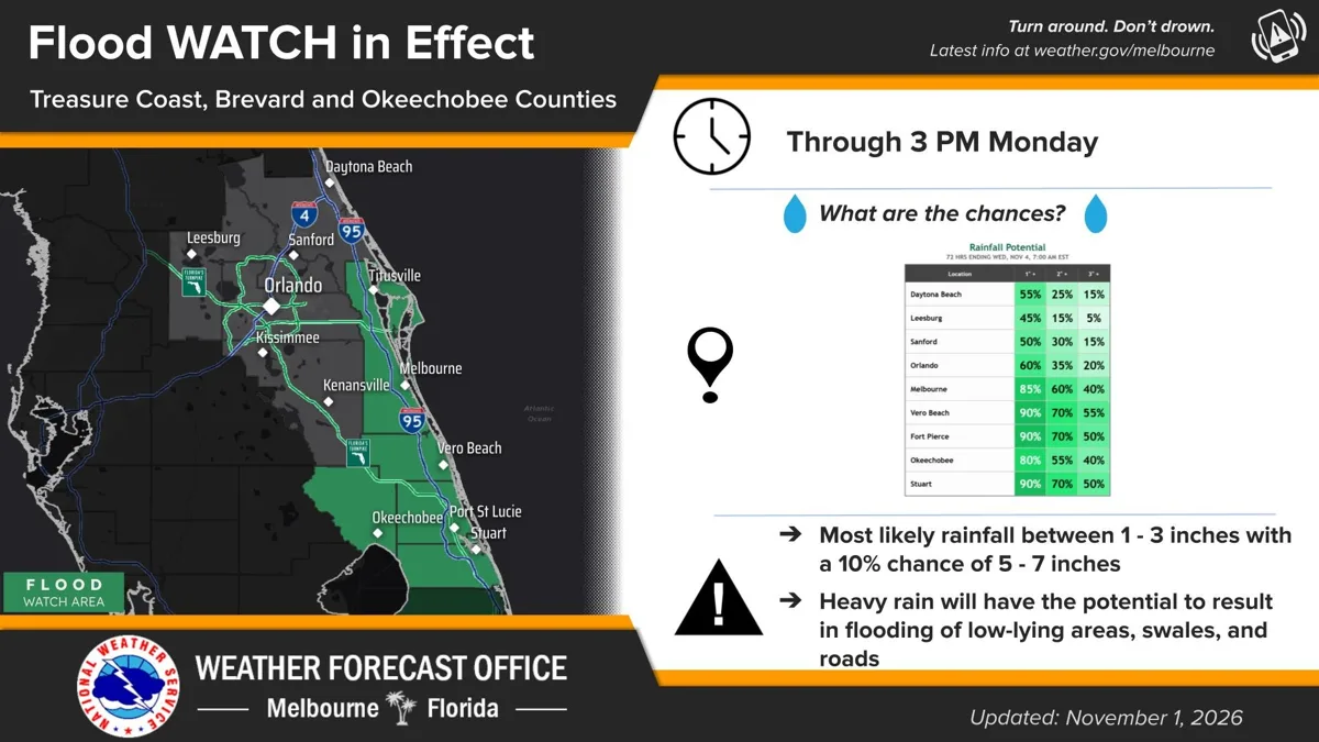
MIAMI, FL, Nov. 1, 2026 — Flood watches now stretch across much of South and Central Florida through 3 p.m. Monday after bands of heavy rain flooded roads from Miami-Dade County to Lake Okeechobee on Sunday, according to the National Weather Service.
Where the flood watches are
- Southeast Florida: NWS Miami put Palm Beach, Broward and Miami-Dade counties, coastal and inland, under a flood watch at 12:49 p.m. Sunday. The office says "scattered locations across the east coast may pick up 3 to 5 inches of rain through Monday," with isolated totals as high as 5 to 7 inches, and impacts "could be greater than forecast if the heaviest rainfall occurs near the coast during times of high tide."
- Glades and Hendry counties: a separate NWS Miami flood watch says some spots have already seen 2 to 4 inches, another 2 to 4 inches is possible through Monday afternoon, and isolated areas could get 4 to 6 more.
- Okeechobee, Brevard and the Treasure Coast: NWS Melbourne issued flood watches at 12:39 p.m. for Okeechobee County and for Brevard, Indian River, St. Lucie and Martin counties. The office says "an approaching disturbance from the Gulf" is meeting "unusually rich moisture," and "the ground is nearly saturated, especially along the Treasure Coast urban corridor."
- Highlands County: NWS Tampa Bay issued a flood watch for Highlands County, saying the ground there is nearly saturated and localized totals of 5 inches or more could cause flash flooding.
What has already fallen
- Okeechobee County: At 2:10 p.m., NWS Melbourne issued a new flash flood warning for southeastern Okeechobee County until 4:15 p.m., saying local law enforcement reported 4 to 7 inches of rain, with 2 to 3 more inches possible. "Flash flooding is already occurring," the warning says. Launchpad Digital reported earlier Sunday on road closures in and around the city of Okeechobee.
- Glades and Hendry counties: a 2:45 p.m. flood advisory says radar and rain gauges show 4.5 to 5.5 inches of rain have fallen in southwestern Glades and northeastern Hendry counties.
- Treasure Coast: a flood advisory until 5:15 p.m. for parts of Indian River, Martin, Okeechobee and St. Lucie counties says 2 to 5 inches have fallen.
- Palm Beach County: a flood advisory for northwestern Palm Beach County reports 3 to 4 inches of rain and water over roadways.
- Miami-Dade County: "Some areas near Cutler Bay have received up to 4 and a half inches over the last few hours," NWS Miami posted on X at 12:25 p.m. "Flooded roadways are likely occurring."
Northeast Florida and the coast
NWS Jacksonville posted on X that localized flooding is possible through Tuesday, mainly along the I-95 corridor and Atlantic coast of Northeast Florida, with 1/2 to 2 inches of rain and localized totals up to 3 to 4 inches.
Along the southeast coast, a coastal flood advisory for Miami-Dade County runs until 7 p.m. Monday, and 5- to 7-foot breaking waves are expected in Palm Beach and Broward counties until 7 a.m. Monday, with a high rip current risk through Tuesday evening.
Staying safe
"Turn around, don't drown when encountering flooded roads. Most flood deaths occur in vehicles," the Okeechobee flash flood warning says. Warnings can be extended, changed or canceled; check weather.gov for the latest in your area.
Launchpad Digital has asked the involved agencies for comment and will update this story when they respond.
Those are the facts, directly from the source.
Note: The National Weather Service alert links in this story stop working once the alerts end. For current alerts at any time, visit weather.gov.
Sources: National Weather Service offices in Miami, Melbourne, Tampa Bay and Jacksonville: active alerts on api.weather.gov as of 2:55 p.m. ET Nov. 1, 2026, and posts by @NWSMiami, @NWSMelbourne and @NWSJacksonville on X.
← More State stories · All Launchpad stories · Spotted an error? Request a correction.