
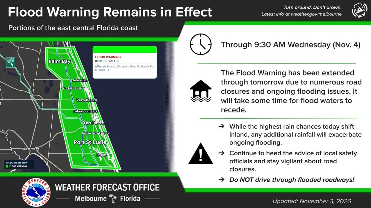
MELBOURNE, FL, Nov. 3, 2026 — The state is sending supplies out of its central warehouse as flooding continues across Central and South Florida, and forecasters say the water in south Brevard and on the Treasure Coast won't drain quickly.
State supplies: The Florida Division of Emergency Management said on X Tuesday that it "continues to move resources" from its Florida Central Operations & Coordination Office warehouse "to support response efforts." The agency says the warehouse holds "3.5 million gallons of drinking water," "3 million shelf-stable meals" and more than 100,000 "tarps, sandbags, dehumidifiers & more, ready to deploy when needed."
Where to get help: The agency asked residents to follow instructions from local emergency management, to call 2-1-1 "for local resources & assistance," and to check its 2026 Fall Flooding page. That page links to emergency management offices in 20 counties, lists the American Red Cross at 1-800-RED-CROSS and a legal services line at 833-514-2940, and links to the Department of Health's list of active boil water notices.
The warning: The National Weather Service in Melbourne issued a flood warning at 9:30 a.m. for southeastern Brevard, eastern Indian River, northeastern Martin and St. Lucie counties until 9:30 a.m. Wednesday. At 9:25 a.m., it said, "emergency management has reported numerous road closures across portions of southern Brevard County and the Treasure Coast." Places expected to see flooding include Port St. Lucie, Palm Bay, Melbourne, Fort Pierce, Sebastian, Stuart and Vero Beach. In an 11 a.m. post, the office said the warning was extended "due to ongoing flooding issues" and told drivers to "never drive through flooded roadways!"
The St. Johns River: Near Cocoa, the river stood at 16.4 feet at 10:15 a.m., just above its 16-foot flood stage, and is forecast to reach moderate flood stage in the next couple of days, "approaching Major Flood Stage late in the week," the Weather Service said. At 17 feet, it says, water approaches low-lying homes in Rockledge's Silver Pines subdivision.
Cleaning up: If you're hauling out flood-damaged items, the state warns not to put lithium-ion batteries in regular trash or debris piles, to avoid handling batteries that are damaged, swollen or have been in floodwater, and to ask your local waste provider how to dispose of them. Our after-the-flood cleanup guide has more.
Turn around at flooded roads, and Launchpad will keep following the rivers this week.
Sources: Florida Division of Emergency Management posts on X (warehouse, help steps, batteries) and its 2026 Fall Flooding page; National Weather Service Melbourne flood warning, St. Johns River near Cocoa warning and 11 a.m. post.
← More Weather stories · All Launchpad stories · Spotted an error? Request a correction.